RailBaltica Geodetic network installation
RAIL BALTICA KAUNAS-RAMYGALA
GEODETIC NETWORK
Total 36 underground geodetic marks built and 112,57 km leveled at III class accuracy.

LiMAP, UAB had a task to build an underground geodetic network as described in the contract. Geodetic network must meet III class leveling accuracy, must be usable for not less than 10 years, must meet Republic of Lithuania legislation and Rail Baltica BIM EIR requirements.
The main Republic of Lithuania laws and regulations applicable for the Services:
– Law of Geodesy and Cartography;
– Technical regulations of Geodesy and Cartography:
– GKTR 2.08.01 “Construction and engineering research” (hereinafter GKTR 2.08.01);
– GKTR 2.07.01 “III and IV class leveling” (hereinafter GKTR 2.07.01);
– GKTR 2.11.03 “A set of topographic spatial objects and agreed signs of topographic spatial objects”.
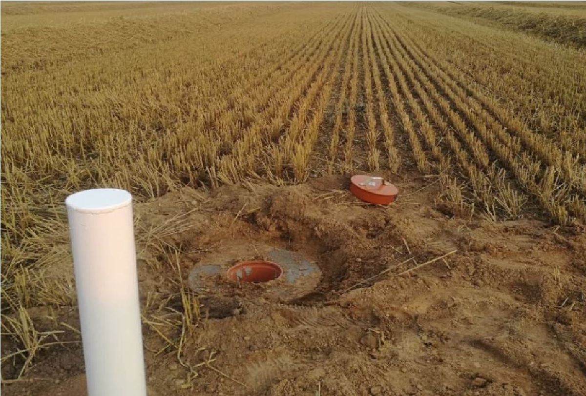
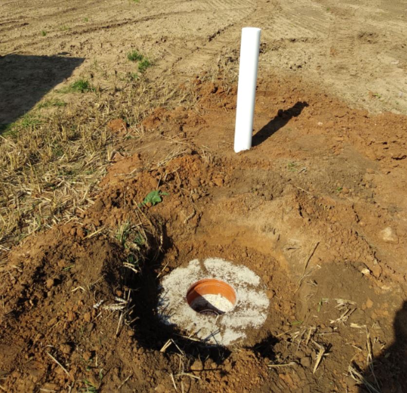
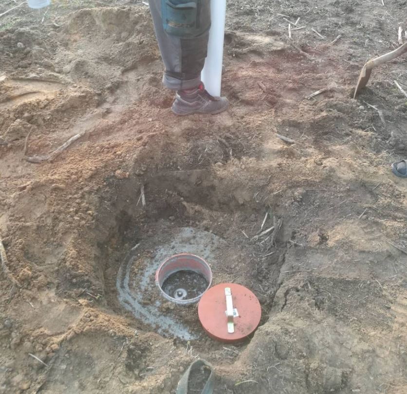
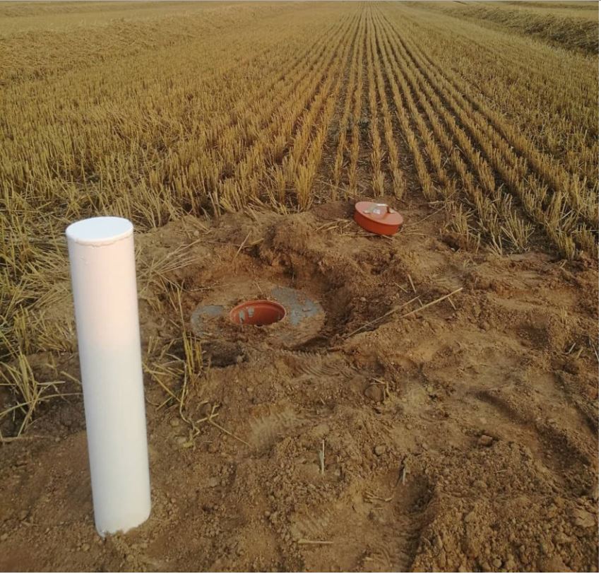
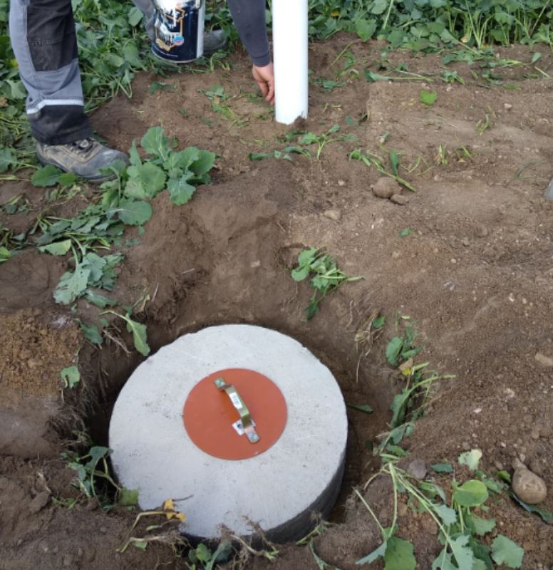
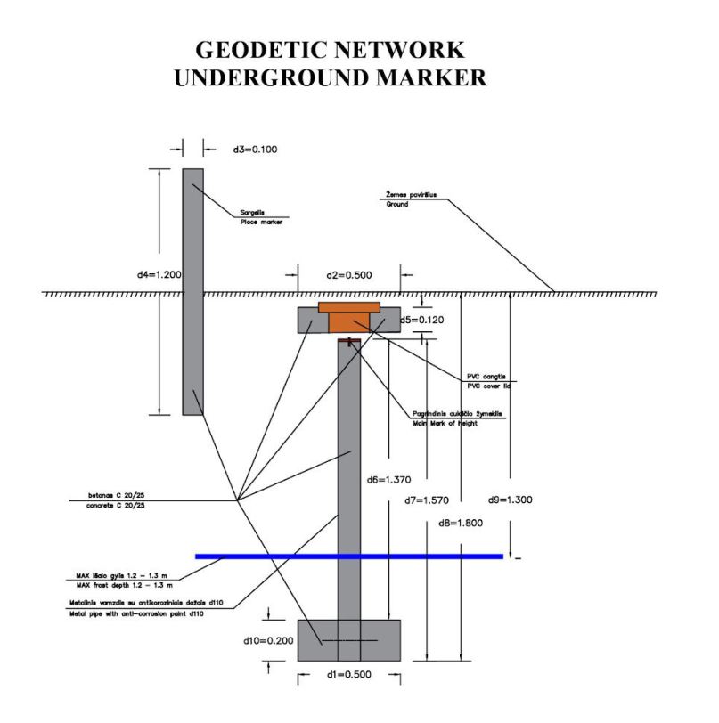
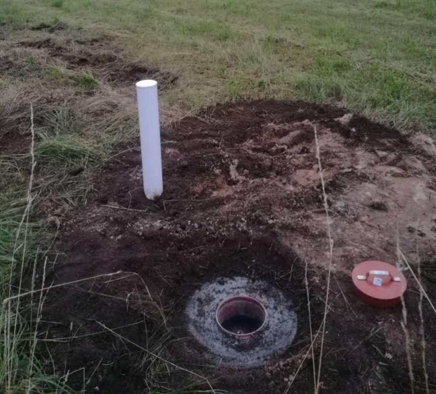
According to GKTR 2.08.01 the gap between the building site’s geodetic network marks for railway construction must not exceed 2 km Geodetic mark is made of concrete and placed underground to save from environmental impact. Base geodetic mark is in 1,6-1,8 meters depth. New underground geodetic marks are built by LiMAP. 50cm diameter holes were drilled with drilling equipment. Concrete plates of 48-50 cm in diameter and 20 cm in height had been placed in the bottom. Metal pipes filled with concrete were encased to the base plate. Pipe was covered with earth and a concrete lid placed on top of it. Plastic cover was placed on top and an upper layer of ground was poured on top.
GKTR 2.07.01 are describing III class leveling rules. For this project following rules apply:
● For territories of 10-50 sq.km III class leveling is done. Allowed polygon or leveling traverse error of leveling closure is , where L is value in km of polygons perime 1 × 0 mm √L ter or leveling traverse length.
● For urban areas maximum polygon perimeter is allowed of 25 km, in rural areas – 40 km. For leveling traverse between higher class leveling marks is not allowed to be more than 15 km, and between nodal marks – 10 km.
● Geodetic network must be connected to the National height base with not less than two higher class geodetic marks in the LAS07 height system.
● After geodetic network leveling, one copy of a report is provided for a municipality.
● Leveling project is done on a map of a scale 1:10000 or higher. All designed and used geodetic marks are shown on a map.
● Designed leveling traverses must be connected to higher or same class geodetic marks.
● For the III class leveling optical levels with micrometers are prefered.
● III class leveling is done in both directions.
● Requirements for level:
○ Standard eyepiece – not less than 30x;
○ Sensitivity of circular level – not more than 30’/2mm;
○ Setting accuracy of compensator (standard deviation) – not more than 0.5”;
● For the III class leveling double sided invar rulers with bars on one side and centimetric splits on the other side are used.
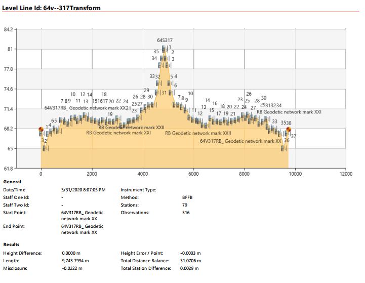
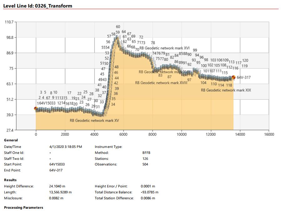
Leica Sprinter 250M was used for leveling geodetic network marks. Brand new level was used for this important task. It is calibrated under regulation of manufacturer Leica Geosystems and tested by LiMAP’s surveyors in the test field. It is not required to do metrological accreditation for new optical survey equipment. Accuracy was compatible with specified in the device’s technical data sheets.
Leica Sprinter 250M level with two invar rulers was used for leveling works. Leveling was carried out by four LiMAP’s land surveying engineers.
Leveling was carried out on 2020-03 – 2020-04. Rail Baltica geodetic markers were built in 2019-08. Average distance from the level to the rulers was from 40 to 65 meters. Same distance to both sides to rulers was used (backward-forward) to reduce earth unevenness. To avoid refraction errors caused by warmth of sunlight leveling were done from early morning till midday. Rulers were placed on hard surfaces with a special base for ruler stability. When the surface was not hard enough to ensure level’s stability, 60x5x4cm wooden stakes with metal fixed screws with spherical heads were placed into the ground at least 0,3 – 0,5 m in depth. Level was placed between two rulers in almost the same distance. In each station measurements of every ruler reading was recorded two times, then it was averaged and this data was used to calculate the traverse. Allowed mismatch is where L is the length of a traverse in ki ± 10mm√L lometers. To prevent level base movement (per 5 minutes level moves 0,01 mm on hard surface, 0,1 mm on the pit), BFFB (backward, forward, forward, backward) symmetrical calculations system was used.